The North Slope Science Catalog (NSSC) facilitates the discovery, distribution and preservation of scientific data and information products. These products assist agencies, organizations, and the public in evaluating the effects of past, ongoing, and anticipated development activities and environmental change on the North Slope. Better access to existing information resources will inform continuing analysis and facilitate data collection efforts by stakeholders. NSSC is a collaborative effort undertaken by NSSI and the University of Alaska.

Web Maps
The web maps below are provided by a variety of sources. Please refer to the web map information (i) button for further description of the data.
Catalog News
| Date Added | Link | Description | Title |
|---|---|---|---|
| 2026-06-03 | CPAI Alpine Helicopter Grid (2026 Summer Season) | CPAI Alpine Helicopter Coordination Grid for the 2026 summer season. | CPAI Alpine Helicopter Grid (2026 Summer Season) |
| 2026-05-04 | 2025-2026 Maternal Polar Bear Den Detection Surveys, North Slope, Alaska | This report summarizes the 2025-2026 aerial infrared surveys searching for maternal polar bear dens near industrial activity in the eastern NPR-A. | 2025-2026 Maternal Polar Bear Den Detection Surveys |
| 2026-05-04 | Fall 2025 Subsistence Fishery Monitoring on the Colville River | This report summarizes the 2025 monitoring of the fall fishery harvest for Arctic Cisco (Qaaktaq) and other subsistence fish species on the Colville River. It provides an overview of local household participation, harvest levels and composition, and the general size and health of fish. | Fall 2025 Subsistence Fishery Monitoring on the Colville River |
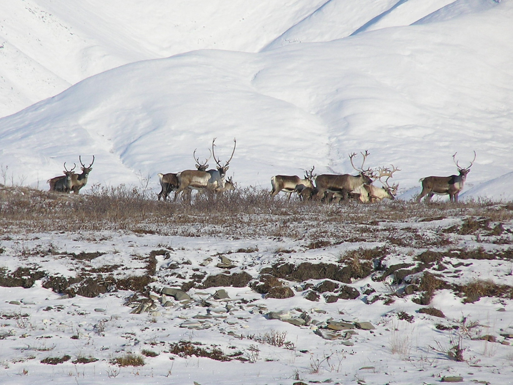
| 2026-05-04 | Caribou Monitoring Study for the Western North Slope Study Area, 2025 | This report summarizes caribou use of the Bear Tooth Unit area from field research conducted in 2025, and analyzes data collected over the life of the project (2001‒2025). | Caribou Monitoring Study for the Western North Slope Study Area, 2025 |
| 2026-04-09 | Final Kaktovik Monitoring Summary Report_R1, 2025 | This report provides summarized data from the Kaktovik Ambient Air Monitoring Project (KAAMP). Data for this report ranges for the duration of the project from October 2021 through the termination of operation in September 2025. | Final Kaktovik Monitoring Summary Report_R1, 2025 |
| 2026-03-02 | Nuiqsut Air Quality Monitoring Station Annual Trends Analysis Report, 2025 | ConocoPhillips Alaska Inc. (CPAI) operates an ambient air quality and meteorology monitoring station in Nuiqsut, Alaska, which is located on the Alaska North Slope. The monitoring program consists of an ambient air quality monitoring station and a meteorological monitoring tower directly mounted to the air quality monitoring structure. The program is designed and operated in accordance with applicable Prevention of Significant Deterioration (PSD) regulations and guidance documents. This is the 2025 Nuiqsut Monitoring Trends Summary. | Nuiqsut Air Quality Monitoring Station Annual Trends Analysis Report, 2025 |
| 2026-03-02 | Nuiqsut Air Quality Monitoring Station Annual Trends Analysis Report, 2024 | ConocoPhillips Alaska Inc. (CPAI) operates an ambient air quality and meteorology monitoring station in Nuiqsut, Alaska, which is located on the Alaska North Slope. The monitoring program consists of an ambient air quality monitoring station and a meteorological monitoring tower directly mounted to the air quality monitoring structure. The program is designed and operated in accordance with applicable Prevention of Significant Deterioration (PSD) regulations and guidance documents. This is the 2024 Nuiqsut Monitoring Trends Summary. | Nuiqsut Air Quality Monitoring Station Annual Trends Analysis Report, 2024 |
| 2026-03-02 | Nuiqsut Air Quality Monitoring Station Annual Trends Analysis Report, 2023 | ConocoPhillips Alaska Inc. (CPAI) operates an ambient air quality and meteorology monitoring station in Nuiqsut, Alaska, which is located on the Alaska North Slope. The monitoring program consists of an ambient air quality monitoring station and a meteorological monitoring tower directly mounted to the air quality monitoring structure. The program is designed and operated in accordance with applicable Prevention of Significant Deterioration (PSD) regulations and guidance documents. This is the 2023 Nuiqsut Monitoring Trends Summary. | Nuiqsut Air Quality Monitoring Station Annual Trends Analysis Report, 2023 |
| 2026-02-26 | Nuiqsut Air and Meteorological Monitoring Program, 2025 | This report provides details of ambient air and meteorological measurements collected during the 2025 monitoring year, spanning from January 1, 2025 to December 31, 2025 at the Nuiqsut monitoring station. | Nuiqsut Air and Meteorological Monitoring Program, 2025 |
| 2026-02-03 | Yellow-Billed Loon Studies in the Willow Project Area, NPR-A, 2025 | In 2025, ABR, Inc. conducted aerial surveys and nest monitoring for Yellow-billed Loons to comply with North Slope Borough stipulations for the Willow Project, marking year 9 of monitoring the area, and the second year of data collection during the construction phase. | Yellow-Billed Loon Studies in the Willow Project Area, NPR-A, 2025 |
| 2026-01-29 | Caribou Use of the Greater Kuparuk Area, Northern Alaska, 2025 | This report investigated the distribution and movements of Central Arctic Herd (CAH) caribou in the Greater Kuparuk Area (GKA) between the Colville and Kuparuk rivers, including the Colville River delta, in northern Alaska during 2024–2025 and compared caribou distribution and movements to previous years with telemetry data available. | Caribou Use of the Greater Kuparuk Area, Northern Alaska, 2025 |
| 2025-12-11 | 2024 Willow Area Fish Sampling | This Final Report presents fish and aquatic data collected during the open water season in 2024 from two streams centrally located in the Willow Development Project Area (Willow Area) in the National Petroleum Reserve-Alaska. | 2024 Willow Area Fish Sampling |
| 2025-12-09 | 2025 WNS-Alpine Eider Nest Search Report | This report summarizes the results of the 2025 survey of alpine eider nests, which included two eider species listed as threatened under the Endangered Species Act of 1973 (as amended, 16 U.S.C. 1531 et seq.): the Spectacled Eider (Somateria fischeri) and the Steller's Eider (Polysticta stelleri). | 2025 WNS-Alpine Eider Nest Search Report |
| 2025-11-21 | 2025 Colville River Delta Spring Breakup Monitoring and Hydrological Assessment | This report presents the observations and results from the 2025 Colville River Delta Spring Breakup Monitoring and Hydrological Assessment conducted by Michael Baker International for ConocoPhillips Alaska. It is the 34th consecutive year of spring breakup investigations and the 38th year of historical breakup monitoring within the Colville River Delta. | 2025 Colville River Delta Spring Breakup Monitoring and Hydrological Assessment |
| 2025-11-13 | Semiannual VOC Monitoring Report, Apr-Sept 2025 | This report summarizes the results on behalf of ConocoPhillips Alaska, Inc. (CPAI), SLR International Corporation (SLR) collected monthly Volatile Organic Compounds (VOC) samples and continuous VOC monitoring data from April 1, 2025 through September 30, 2025 at both the CD1 and Nuiqsut air monitoring stations, located on the Alaskan North Slope. | Semiannual VOC Monitoring Report, Apr-Sept 2025 |
| 2025-10-07 | Nuiqsut Caribou Subsistence Monitoring Year 16 | This report presents the 2023 (Year 16) study year data for the Nuiqsut Caribou Subsistence Monitoring Project based on research conducted by Stephen R. Braund & Associates (SRB&A) under contract to ConocoPhillips Alaska, Inc. (CPAI). | Nuiqsut Caribou Subsistence Monitoring Year 16 |
| 2025-10-06 | Eider Studies for GMT1 and Willow Project Area, 2020-2024 | This report is the final year of a 5-year study (2020–2024) focused on King Eiders (Somateria spectabilis), and Spectacled Eiders (S. fischeri) recorded opportunistically, in the Greater Mooses Tooth (GMT) and Willow project areas to comply with rezone stipulations set forth by the North Slope Borough (NSB). | Eider Studies for GMT1 and Willow Project Area, 2020-2024 |
| 2025-08-11 | 2025 Willow Spring Breakup Culvert Monitoring Report | This report presents hydrological and hydraulic (H&H) monitoring of the Willow Pass culvert and gravel fill during the 2025 spring thaw season. | 2025 Willow Spring Breakup Culvert Monitoring Report |
| 2025-07-10 | 2024 Willow Spring Breakup Report& Hydrological Assessment | This report presents the results from the 2024 Willow Spring Breakup and Summer Monitoring and Hydrological Assessment conducted by Michael Baker International for ConocoPhillips Alaska, Inc. The monitoring and hydrological assessment supports the National Petroleum Reserve – Alaska Integrated Activity Plan by assessing the relative magnitude of spring breakup floodwater and summer hydrologic conditions. The analyses also provide data to support design and permitting. | 2024 Willow Spring Breakup Report& Hydrological Assessment |
| 2025-06-06 | Semiannual VOC Monitoring Report, Oct 2024 - March 2025 | This report summarizes the results on behalf of ConocoPhillips Alaska, Inc. (CPAI), SLR International Corporation (SLR) collected monthly Volatile Organic Compounds (VOC) samples and continuous VOC monitoring data from October 2024 through March 2025. | Semiannual VOC Monitoring Report, Oct 2024 - March 2025 |
| 2025-04-28 | 2024/2025 Maternal Polar Bear Den Detection Surveys, North Slope, Alaska | This report describes the 2024/2025 aerial FLIR surveys targeting polar bear denning habitat by ConocoPhillips Alaska, Inc. (CPAI). | 2024/2025 Maternal Polar Bear Den Detection Surveys, North Slope, Alaska |
| 2025-04-17 | Fall 2024 Subsistence Fishery Monitoring on the Colville River | This report summarizes the results of the 2024 (the 39th year) studies to monitor effort of the Colville River fall fishery. | Fall 2024 Subsistence Fishery Monitoring on the Colville River |
| 2025-04-10 | Caribou Monitoring Study for the Alpine Oilfield and Greater Mooses Tooth Unit, 2024 | This report summarizes field research conducted in 2024, and analyses of data collected over the life of the Caribou use of the greater Alpine Oilfield (previously referred to as the Alpine Satellite Development Program [ASDP]) including the Greater Mooses Tooth (GMT) drill sites has been studied since 2001. | Caribou Monitoring Study for the Alpine Oilfield and Greater Mooses Tooth Unit, 2024 |
| 2025-04-01 | Avian Studies in the Willow Project Area, 2024 | This report was ABR conducted their 8th year of aerial surveys for Yellow-billed Loons (Gavia adamsii) in the Willow Project area. | Avian Studies in the Willow Project Area, 2024 |
| 2025-02-25 | Avian Studies on the Coville River Delta, Alaska, 2024 | In 2024, ABR conducted aerial surveys for nesting and brood-rearing Yellow-billed Loons (Gavia adamsii) in the Colville Delta study area in accordance with the Alpine-GMT consolidated rezone ordinance. | Avian Studies on the Coville River Delta, Alaska, 2024 |
| 2025-02-24 | Caribou Monitoring Study for the Bear Tooth Unit, Alaska, 2024 | Caribou use of the Bear Tooth Unit area has been studied since 2001. This report summarizes field research conducted in 2024, and analyses of data collected over the life of the project. | Caribou Monitoring Study for the Bear Tooth Unit, Alaska, 2024 |
| 2025-02-24 | Nuiqsut Air and Meteorological Monitoring Program, 2024 | This report provides details of ambient air and meteorological measurements collected during the 2024 monitoring year, spanning from January 1, 2024 to December 31, 2024 at the Nuiqsut monitoring station. | Nuiqsut Air and Meteorological Monitoring Program, 2024 |
| 2025-02-14 | 2024 Shorebird Monitoring in the Willow Project Area | This report was the fourth consecutive year of monitoring and the first year of construction activity in the study area by ABR, Inc. Approximately 11.5 km of road and the Willow Operations Center pad were constructed in the project area during the winter of 2023–2024, and heavy machinery started compacting and conditioning the gravel in late June. | 2024 Shorebird Monitoring in the Willow Project Area |
| 2025-02-12 | Caribou Use of the Greater Kuparuk Area, Northern Alaska, 2024 | This study investigated the distribution and movements of Central Arctic Herd (CAH) caribou in the Greater Kuparuk Area (GKA) between the Colville and Kuparuk rivers in northern Alaska during 2023–2024 and compared caribou distribution and movements to previous years with telemetry data available. | Caribou Use of the Greater Kuparuk Area, Northern Alaska, 2024 |
| 2024-12-20 | Kaktovik, Alaska Ambient Air Monitoring Station: Annual Data Summary Report for October 1, 2023– September 30, 2024 | This annual data report provides summarized data from the third year of the Kaktovik Ambient Air Monitoring Project (KAAMP). Data for this report ranges from the first day of Q4 2023 (October 1, 2023) through the last day of Q3 2024 (September 30, 2024). | Kaktovik, Alaska Ambient Air Monitoring Station: Annual Data Summary Report for October 1, 2023– September 30, 2024 |
| 2024-12-06 | Semiannual VOC Monitoring Report, Apr-Sept 2024 | This report summarizes the results on behalf of ConocoPhillips Alaska, Inc. (CPAI), SLR International Corporation (SLR) collected monthly Volatile Organic Compounds (VOC) samples and continuous VOC monitoring data from April 23, 2024, through September 23, 2024 at both the CD1 and Nuiqsut air monitoring stations. | Semiannual VOC Monitoring Report, Apr-Sept 2024 |
| 2024-12-03 | Eider Nest Searches in the Alpine Oilfield Area, Alaska, 2024 | This report summarizes results of 2024 Alpine Eider (the Spectacled Eider and the Steller’s Eider) nest surveys. | Eider Nest Searches in the Alpine Oilfield Area, Alaska, 2024 |
| 2024-11-27 | 2024 Colville River Delta Region Spring Breakup Monitoring Hydrological Assessment | This report presents the observations and results from the 2024 Colville River Delta Spring Breakup Monitoring and Hydrological Assessment conducted by Michael Baker International for ConocoPhillips Alaska. It is the 33rd consecutive year of spring breakup investigations and the 38th year of historical breakup monitoring within the Colville River Delta. | 2024 Colville River Delta Region Spring Breakup Monitoring Hydrological Assessment |
| 2024-11-13 | Summaries of CPAI Environmental Studies, 2024 | This booklet contains the one-page summaries of the biological and physical environmental field studies conducted in the Alpine and Kuparuk areas and the NPR-A during calendar year 2024. | Summaries of CPAI Environmental Studies, 2024 |
| 2024-10-30 | Q3 2024 Kaktovik Data Summary Report | This report presents the meteorological and pollutant data collected at the Bureau of Land Management (BLM) Kaktovik Ambient Air Monitoring Project (KAAMP) station in the third quarter of 2024 (Q3 2024). Meteorological data completeness statistics for Q3 2024 are listed. | Q3 2024 Kaktovik Data Summary Report |
| 2024-10-30 | Appendices Q3 2024 Kaktovik Data Summary Report | Appendices for Kaktovik, Alaska Ambient Air Monitoring Station: Data Summary Report for July – September 2024 | Appendices Q3 2024 Kaktovik Data Summary Report |
| 2024-09-10 | 2023 Tiŋmiaqsuigvik River and Willow Area Fish Sampling | This Final Report presents fish and aquatic data collected during the open water season in 2023 from two areas within the National Petroleum Reserve-Alaska (NPR–A): the Tiŋmiaqsiugvik (Ublutuoch) River drainage and two streams centrally located in the proposed Willow Development Project Area, referred to hereafter as the Willow Area. | 2023 Tiŋmiaqsuigvik River and Willow Area Fish Sampling |
| 2024-09-10 | Nuiqsut Caribou Subsistence Monitoring Year 15 | This report presents the 2022 (Year 15) study year data for the Nuiqsut Caribou Subsistence Monitoring Project based on research conducted by Stephen R. Braund & Associates (SRB&A) under contract to ConocoPhillips Alaska, Inc. (CPAI). | Nuiqsut Caribou Subsistence Monitoring Year 15 |
| 2024-06-21 | Q4 2023 Kaktovik Report | This report presents the meteorological and pollutant data collected at the Bureau of Land Management (BLM) Kaktovik Ambient Air Monitoring Project (KAAMP) station from October 1, 2023 to December 31, 2023 (4th Quarter 2023). Monitoring was performed in accordance with the approved Kaktovik, Alaska Ambient Air Monitoring Station Quality Assurance Project Plan, Air Sciences Inc. 2022 (QAPP). | Q4 2023 Kaktovik Report |
| 2024-06-21 | Appendices Q4 2023 Kaktovik Report | Appendices for Kaktovik, Alaska Ambient Air Monitoring Station: Data Summary Report for October – December 2023 | Appendices Q4 2023 Kaktovik Report |
| 2024-06-21 | Kaktovik HAPs Data Summary Report - June 2024 | This data summary report presents the hazardous air pollutant (“HAP” or “HAPs”) data collected at the Bureau of Land Management (BLM) Kaktovik Ambient Air Monitoring Project (KAAMP) station from January 18, 2022, to April 19, 2024. Monitoring was performed in accordance with the scope of work prepared by the Pinyon Team for BLM. | Kaktovik HAPs Data Summary Report - June 2024 |
| 2024-05-30 | CPAI Alpine Helicopter Grid (2024 Summer Season) | CPAI Alpine Helicopter Coordination Grid for the 2024 summer season. | CPAI Alpine Helicopter Grid (2024 Summer Season) |
| 2024-05-15 | Semiannual VOC Monitoring Report Oct 2023 - March 2024 | This report summarizes the results obtained from October 2023 through March 2024. ConocoPhillips Alaska, Inc. (CPAI) has operated an ambient air quality and dispersion meteorology monitoring station in Nuiqsut, Alaska, which is located on the Alaskan North Slope. The monitoring station is located at the northern edge of Nuiqsut approximately 400 meters north-northwest of the community electrical generators. | Semiannual VOC Monitoring Report Oct 2023 - March 2024 |
| 2024-05-08 | Fall 2023 Subsistence Fishery Monitoring on the Colville River | This report summarizes the results of the 2023 (the 38th year) studies to monitor effort of the Colville River fall fishery. | Fall 2023 Subsistence Fishery Monitoring on the Colville River |
| 2024-05-01 | 2023/2024 Maternal Polar Bear Den Detection Surveys North Slope, Alaska | This report describes the 2023/2024 aerial FLIR surveys targeting polar bear denning habitat by ConocoPhillips Alaska, Inc. (CPAI). | 2023/2024 Maternal Polar Bear Den Detection Surveys North Slope, Alaska |
| 2024-04-23 | Caribou Monitoring Study for the Bear Tooth Unit, Arctic Coastal Plain, Alaska, 2023 | This report summarizes field research on caribou use of the Beartooth Unit area in 2023 and analysis of data collected over the life of the project. | Caribou Monitoring Study for the Bear Tooth Unit, Arctic Coastal Plain, Alaska, 2023 |
| 2024-04-02 | Nuiqsut All Resources 10-Year Subsistence Mapping Study, 2024 | This 2024 final report includes All Resources 10-Year Subsistence Mapping Study of Nuiqsut, Alaska as part of the Nuiqsut Caribou Subsistence Project. | Nuiqsut All Resources 10-Year Subsistence Mapping Study, 2024 |
| 2024-04-01 | Willow Spring Breakup Monitoring and Hydrological Assessment, 2023 | This report presents the results from the 2023 Willow Spring Breakup and Summer Monitoring and Hydrological Assessment conducted by Michael Baker International for ConocoPhillips Alaska, Inc. The analyses also provide data to support design and permitting. Monitoring reports from 2018 are also available. | Willow Spring Breakup Monitoring and Hydrological Assessment, 2023 |
| 2024-03-04 | Caribou Monitoring Study for the Alpine Oilfield and Greater Mooses Tooth Unit, 2023 | This 2023 report takes an inside look at caribou's use of the Great Alpine oil fields (previously referred to as the Alpine Satellite Development Program (ASDP) and Greater Moose’s Tooth (GMT) Unit areas has been studied since 2001) | Caribou Monitoring Study for the Alpine Oilfield and Greater Mooses Tooth Unit, 2023 |
| 2024-02-20 | Yellow-billed Loon and Goose Studies in the Willow Project Area, NPR-A, 2023 | In 2023, Repeat avian surveys have been conducted in the Willow Project area of the NE NPR-A since 2017. The surveys were designed to collect data on the distribution, abundance and habitat use of 2 focal taxa in support of permit application: Spectacled Eider ( Somateria fisheri) and Yellow-billed Loon (Gavia adamsii). | Yellow-billed Loon and Goose Studies in the Willow Project Area, NPR-A, 2023 |
| 2024-02-20 | Nuiqsut Air and Meteorological Monitoring Program, 2023 | This report provides details of ambient air and meteorological measurements collected during the 2023 monitoring year, spanning from January 1, 2023, to December 31, 2023, at the Nuiqsut monitoring station. | Nuiqsut Air and Meteorological Monitoring Program, 2023 |
| 2024-02-15 | Shorebird Monitoring in the Willow Project Area, NPR-A, 2023 | This reports presents the third and final year of pre-development baseline data collection. Approximately 4 km of road was constructed in the project area during the winter of 2023. | Shorebird Monitoring in the Willow Project Area, NPR-A, 2023 |
| 2024-02-14 | Eider Studies for Greater Mooses Tooth and the Willow Project Area, NPR-A, 2023 | This 2023 report documents the 4th year of a 5-year study focused on King Eiders (Somateria spectabilis) with Spectacled Eiders (S. fischeri) recorded opportunistically in two new oil developments in support of GMT rezone stipulations. | Eider Studies for Greater Mooses Tooth and the Willow Project Area, NPR-A, 2023 |
| 2024-02-13 | Caribou Use of the Greater Kuparuk Area, Northern Alaska, 2023 | This study investigated the distribution and movements of Central Arctic Herd (CAH) caribou during 2022–2023 and compared caribou distribution and movementsto previous years with telemetry data available. | Caribou Use of the Greater Kuparuk Area, Northern Alaska, 2023 |
| 2024-02-12 | Avian Studies on the Colville River Delta, 2023 | This report summarizes ABR's 2023 avian studies for the Alpine Satellite Development Project (ASDP). | Avian Studies on the Colville River Delta, 2023 |
| 2024-01-04 | ASRC Mine Site Dewatering Project, Rolligon Disturbance, 2013-2023 | In August 2013, ConocoPhillips Alaska, Inc. (CPAI) conducted tundra travel using rolligons as part of an effort to dewater the Arctic Slope Regional Corporation (ASRC) Mine Site. This report should lead to a better understanding of vegetation response after 10 years treatment. | ASRC Mine Site Dewatering Project, Rolligon Disturbance, 2013-2023 |
| 2023-12-14 | Summer 2022 Subsistence Fishery Monitoring on the Colville River, Alaska | This report summarizes the results of the 2022 studies to monitor the summer subsistence gillnet harvest of fish in the Nigliq Channel of the Colville. | Summer 2022 Subsistence Fishery Monitoring on the Colville River, Alaska |
| 2023-12-01 | 2023 Colville River Delta Spring Breakup Monitoring and Hydrological Assessment | The 2023 monitoring and hydrological assessment is the 32nd consecutive year of spring breakup investigations and the 37th year of historical breakup monitoring in the Colville River Delta. | 2023 Colville River Delta Spring Breakup Monitoring and Hydrological Assessment |
| 2023-11-29 | Eider Nest Searches in the Alpine Oilfield Area, Alaska, 2023 | This report summarizes results of 2023 Alpine Eider (the Spectacled Eider and the Steller’s Eider) nest surveys. | Eider Nest Searches in the Alpine Oilfield Area, Alaska, 2023 |
| 2023-11-20 | Tinmiaqsiugvik River and Willow Area Fish Sampling 2022 Final Report | This report documents the 2022 results of fish sampling in the Tiŋmiaqsiugvik River drainage (also known as the Ublutuoch River). | Tinmiaqsiugvik River and Willow Area Fish Sampling 2022 Final Report |
| 2023-11-20 | Caribou Monitoring Study for the Bear Tooth Unit Arctic Coastal Plain, Alaska, 2022 | The caribou monitoring study for the Bear Tooth Unit (BTU) area was conducted on the Arctic Coastal Plain of northern Alaska in the northeastern portion of the National Petroleum Reserve–Alaska. Results for 2022 were added. | Caribou Monitoring Study for the Bear Tooth Unit Arctic Coastal Plain, Alaska, 2022 |
| 2023-11-16 | Volatile Organic Compounds Near the Village of Nuiqsut, Alaska | ConocoPhillips Alaska, Inc. (CPAI) has operated an ambient air quality and dispersion meteorology monitoring station to monitor air quality in Nuiqsut, Alaska. This report summarizes the results obtained from April 2023 through September 2023 | Volatile Organic Compounds Near the Village of Nuiqsut, Alaska |
| 2023-10-31 | Summaries of CPAI Environmental Studies, 2023 | These reports provide summaries of 2023 CPAI environmental studies conducted in the Colville River and NPR-A regions of the North Slope. | Summaries of CPAI Environmental Studies, 2023 |
| 2023-10-26 | 2022-2023 Maternal Polar Bear Den Detection AIR Surveys | This report describes the 2022/2023 aerial FLIR surveys targeting polar bear denning habitat within one mile of planned or ongoing industry activity. | 2022-2023 Maternal Polar Bear Den Detection AIR Surveys |
| 2023-10-23 | Shorebird Monitoring in the Willow Project Area, 2022 | This reports presents the 2022 (Year 2) on assessing predevelopment baseline conditions for nesting shorebirds in the Willow Project area. | Shorebird Monitoring in the Willow Project Area, 2022 |
| 2023-09-18 | Caribou Monitoring Study for the Alpine Satellite Development Program and Greater Moose's Tooth Unit, 2022 | Caribou use of the Alpine Satellite Development (ASDP) and Greater Mooses Tooth (GMT) Unit areas has been studied since 2001. This report summarizes field research conducted in 2022 and analyses of data collected over the life of the project. | Caribou Monitoring Study for the Alpine Satellite Development Program and Greater Moose's Tooth Unit, 2022 |
| 2023-07-24 | Nuiqsut Caribou Subsistence Monitoring Y14 Report | This report presents the 2021 (Year 14) study year data for the Nuiqsut Caribou Subsistence Monitoring Project based on research conducted by Stephen R. Braund & Associates (SRB&A) under contract to ConocoPhillips Alaska, Inc. (CPAI). | Nuiqsut Caribou Subsistence Monitoring Y14 Report |
| 2023-07-24 | Fall 2022 Subsistence Fishery Monitoring on the Colville River | This is the 37th year of industry-sponsored harvest monitoring effort of the Colville River fall fishery. | Fall 2022 Subsistence Fishery Monitoring on the Colville River |
| 2023-05-18 | Eider Studies for Greater Mooses Tooth and Proposed Willow Projects, NPR-A, 2022 | This report documents the third year of a 5-year study focused on King Eiders (Somateria spectabilis) with Spectacled Eiders (S. fischeri) recorded opportunistically in two new oil developments in support of GMT rezone stipulations. | Eider Studies for Greater Mooses Tooth and Proposed Willow Projects, NPR-A, 2022 |
| 2023-05-10 | Semiannual VOC Monitoring Report, Oct 2022-March 2023 | ConocoPhillips Alaska, Inc. (CPAI) has operated an ambient air quality and dispersion meteorology monitoring station in Nuiqsut, Alaska, which is located on the Alaskan North Slope. The monitoring station is located at the northern edge of Nuiqsut approximately 400 meters north-northwest of the community electrical generators. This report summarizes the results obtained from October 2022 through March 2023. | Semiannual VOC Monitoring Report, Oct 2022-March 2023 |
| 2023-05-10 | Kaktovik, Alaska Ambient Air Monitoring Station: Data Summary Report for January – March 2023 | The primary objective of this effort is to collect continuous year-round meteorological and air pollutant data with near adherence to pertinent PSD monitoring requirements in the vicinity of the village of Kaktovik on Barter Island, Alaska. | Kaktovik, Alaska Ambient Air Monitoring Station: Data Summary Report for January – March 2023 |
| 2023-05-03 | Yellow-Billed Loon and Goose Studies in the Willow Project Area, 2022 | 2022, ABR conducted aerial surveys for Yellow-billed Loons (tuullik), and molting Pacific Black Brant (niġlinġaq), Cackling/Canada goose (iqsraġutilik), Greater White-fronted Goose (niġliviq), and Lesser Snow Goose (kaŋuq) in the Willow project area to comply with rezone stipulations set forth by the North Slope Borough. | Yellow-Billed Loon and Goose Studies in The Willow Project Area, National Petroleum Reserve-Alaska, 2022 |
| 2023-05-01 | Avian Studies for the Alpine Oilfield, 2022 | 2022 marked the 20th year of avian studies conducted by ABR for the Alpine Satellite Development Project. In 2022, surveys focused on eiders, oons, and brood-rearing geese. Other avian studies conducted for CPAI in 2022 included aerial surveys for loons and molting geese in the Willow Project area | Avian Studies for the Alpine Oilfield, 2022 |
| 2023-05-01 | Caribou Use of the Greater Kuparuk Area, Northern Alaska, 2022, | This study investigated the distribution and movements of Central Arctic Herd (CAH) caribou in 2021–2022 in the Greater Kuparuk Area (GKA) between the Colville and Kuparuk rivers in northern Alaska. | Caribou Use of The Greater Kuparuk Area, Northern Alaska, 2022 |
| 2023-03-22 | North Slope Infrastructure (V13): Roads, Pipelines and Developed Areas, 2023 | North Slope infrastructure GIS datasets have been updated using 2022 Sentinel imagery for the oil field development area and other image products as available for the greater North Slope region. | NSInfra_V13 geodatabase and shapefiles |
| 2023-03-09 | Summary of CPAI Environmental Studies, 2022 | These reports provide summaries of CPAI environmental studies (2020-2022) conducted in the Colville River and NPR-A regions of the North Slope. | Summary of CPAI Environmental Studies, 2022 |
| 2023-03-07 | Nuiqsut Air and Meteorological Monitoring Program, Trend Report and Annual Report | Since April 9, 1999, CPAI has operated an ambient air quality and dispersion meteorology monitoring station in Nuiqsut, Alaska, which is located on the Alaskan North Slope. These reports document yearly data and provide trend analysis. | Nuiqsut Air and Meteorological Monitoring Program, 2021.pdf Nuiqsut Air and Meteorological Monitoring Program, 2022.pdf Nuiqsut Air Quality Monitoring Annual Trends Analysis 2022.pdf |
| 2023-02-18 | Survey of Lakes in ConocoPhillips Activity Areas, 2022 | Thirteen lakes were sampled for fish presence, water depth, and water quality. All surveys were conducted to support planned Willow Area infrastructure design and potential use of water during winter operations and exploration activities. | Survey of Lakes in ConocoPhillips Activity Areas, 2022 |
| 2023-02-13 | Tiŋmiaqsiugvik River and Willow Area Fish Sampling (2020-2021) | These reports document the results of fish sampling in the Tiŋmiaqsiugvik River drainage (also known as the Ublutuoch River) during the 2020-21 project years. The primary goals of the sampling was to determine the fish species using the drainage and to describe seasonal use patterns within the river and tributaries. | Tiŋmiaqsiugvik River and Willow Area Fish Sampling 2021 Final Report |
| 2023-02-13 | Fish Surveys in the Northeastern NPR-A (2018-2020) | This report documents the results of fish surveys conducted at streams crossed by permanent gravel infrastructure during 2020 monitoring. Additional reports available for 2018-19 project years. | Fish Surveys in the Willow Project Area Northeastern NPR–A 2020 Final Report |
| 2023-02-10 | Kaktovik Ambient Air Monitoring Annual Data Summary Report, 2022 | This annual report presents the meteorological and pollutant data collected at the Bureau of Land Management (BLM) Kaktovik Ambient Air Monitoring Project (KAAMP) station during Q4 2021 (October 1, 2021) through Q3 2022 (September 30, 2022). | Kaktovik, Alaska Ambient Air Monitoring Station: Annual Data Summary Report for October 15, 2021– September 30, 2022 |
| 2023-01-19 | Yellow-billed Loon and Goose Studies in the Willow Project Area, 2021 | Repeat avian surveys have been conducted in the Willow Project area of the NE NPR-A since 2017. The surveys were designed to collect data on the distribution, abundance and habitat use of 2 focal taxa in support of permit application: Spectacled Eider ( Somateria fisheri) and Yellow-billed Loon (Gavia adamsii). | Yellow-billed Loon and Goose Studies in the Willow Project Area, 2021 |
| 2023-01-19 | ADOG North Slope Oil and Gas Activity and Units Map | The Oil and Gas Activity and Units Map for the North Slope region has been updated. | ADOG North Slope Oil and Gas Activity and Units Map |
| 2023-01-06 | ASDP Water Quality Monitoring, 2022 | Alpine Satellite Development Plan (ASDP) water quality monitoring for 2022. Prior report since 1999 also available. Work included in-situ field sampling for temperature, conductivity/specific conductance, dissolved oxygen (DO), salinity, turbidity, and pH. Water samples were collected at each lake for laboratory analyses of dissolved hydrocarbons: diesel range organics (DRO), residual range organics (RRO), and Resource Conservation and Recovery Act (RCRA) metals.Insitu water quality parameters included: total depth, temperature, turbidity, conductivity, specific conductance, dissolved oxygen, salinity and pH. Laboratory analysis included: RCRA metals, DRO and RRO. | Alpine and Willow Water Quality Reports (1999-2022) |
| 2023-01-06 | Willow Spring Breakup Report, 2022 | This 2022 assessment supports the National Petroleum Reserve – Alaska Integrated Activity Plan by assessing the relative magnitude of spring breakup floodwater and summer hydrologic conditions. The analyses also provide data to support design and permitting. Monitoring reports from 2018 are also available. | Willow Spring Breakup Monitoring and Hydrological Assessment |
| 2023-01-06 | CRD Spring Breakup Monitoring and Hydrological Assessment, 2022 | These reports present the observations and results from the Colville River Delta CRD) Spring Breakup Monitoring and Hydrological Assessment for the Alpine Facilities. The 2022 monitoring and hydrological assessment is the 31st consecutive year of spring breakup investigations and the 36th year of historical breakup monitoring in the Colville River Delta. Prior reports are also available. | Colville River Delta Region Spring Breakup Monitoring Hydrological Assessment |
| 2023-01-06 | Semiannual VOC Monitoring Report, April-Sept 2022 | This report summarizes findings for VOC monitoring during April-September 2022. The monitoring program began in February 2014 to determine if VOC concentrations could be detected in the ambient air in and near Nuiqsut, Alaska. An additional study objective was to evaluate the sampling methodology in the arctic environment and the logistics of transporting samples to the laboratory. Prior reports are also available. | Nuiqsut volatile organic compound (VOC) Monitoring |
| 2023-01-06 | Alpine Eider Nest Surveys, 2022 | This report summarizes results of 2022 Alpine Eider nest surveys. Spectacled Eiders (Somateria fisheri) population status on the North Slope is being monitored. Annual surveys for Spectacled Eiders began in the Kuparuk Oilfield in 1993 and have included searches for King Eiders (Somateria spectabilis) which nest in similar habitats. Prior reports are also available. | Alpine Eider Nest Surveys |
| 2022-11-10 | Data Visualization Portals | Web maps were updated for: Infrastructure and Landownership; Permafrost Mapping and Borehole Database; Ecological Mapping and Field Site Photos; and North Slope Lakes Winter Unfrozen Water. | Data Portals |
| 2022-11-02 | ConocoPhillips Environmental Study Summaries (2022) | This report provides summaries of 2022 CPAI environmental studies conducted in the Colville River and NPR-A regions of the North Slope. | Summaries of 2022 Environmental Field Studies |
| 2022-10-15 | North Slope Infrastructure Update | Updated infrastructure layer (V12) in NEIW and Infrastructure/Landownership Portals | Infrastructure V12 Update |
| 2022-10-14 | Permafrost Borehole Portal Update | Upper permafrost characteristics portal has been updated with additional borehole information. | Upper Permafrost Characteristics |
| 2022-10-12 | ADOG Working Interest Ownership Map | The Working Interest Ownership Map for the North Slope region has been updated by ADOG. | North Slope Oil and Gas Working Interest Ownership |
| 2022-09-08 | Nuiqsut Caribou Subsistence Monitoring Project: 2020 (Year 13) Report | This report presents the 2020 (Year 13) study year data for the Nuiqsut Caribou Subsistence Monitoring Project which documents impacts of CD4 and other CPAI satellite developments on Nuiqsut residents’ caribou hunting activities. This report is based primarily on hunter observations and a household caribou harvest survey. | Nuiqsut Caribou Subsistence Monitoring Project: 2020 (Year 13) Report |
| 2022-09-08 | NSSI North Slope Infrastructure (V12): Roads, Pipelines and Developed Areas | The North Slope infrastructure GIS data set has been updated to include additional road and developed area features. | North Slope Infrastructure GIS Data |
| 2022-09-08 | NSSC System Maintenance | NSSC will be down for system maintenance starting at 2pm Friday Sept 9. | System Maintenance |
| 2022-09-01 | NSSC System Maintenance | NSSC will be down for system maintenance starting at 2pm Friday Sept 2 and will be back up by Monday Sept 5. | System Maintenance |
| 2022-06-30 | NSSI North Slope Infrastructure (V11): Roads, Pipelines and Developed Areas | The North Slope infrastructure GIS data set has been updated based on recent high resolution imagery. Geolocation accuracy is improved and more consistent throughout the study area. | North Slope Infrastructure GIS Data |
| 2022-06-29 | IMIQ: Hydro/Climate Data Rescue, Standardization and Distribution | The Imiq database is now available at a new website. This multi-year data rescue effort brought together scarce and scattered meteorology/hydrology datasets and placed them in one data structure and location. Data values have been normalized to allow comparison over time/space. | Imiq Database Website |
| 2022-05-24 | Nuiqsut Air Quality Reports 3/1/2022-5/22/2022 | A continuous air quality monitoring station operates in the community of Nuiqsut that meets EPA standards for the National Ambient Air Quality Standards (NAAQS). Nuiqsut Air Quality Monitoring reports based on NAAQS data are provided for 03/01-05/22, 2022. | Nuiqsut Air Quality Monitoring Report |
| 2022-05-09 | Polar Bear Den Detection Surveys, North Slope 2021-2022 | This report describes the 2021/2022 aerial FLIR surveys targeting polar bear denning habitat within one mile of planned or ongoing industry activity. | 2021-2022 CPAI Polar Bear Den Detection AIR Survey Report.pdf |
| 2022-05-05 | Summer Subsistence Fishery Monitoring on the Nigliq Channel of the Colville River, 2021 | This report summarizes the results of the first year of studies to monitor the summer subsistence gillnet harvest of fish in the Nigliq Channel of the Colville. | 2021 Colville River Summer Fishery.pdf |
| 2022-04-29 | Fall Subsistence Fishery Monitoring on the Colville River, 2021 | This report provides monitoring results of the Nuiqsut fall harvest of Arctic Cisco on the Colville River. Monitoring of this fishery has been conducted since the mid-1980s. | 2021 Colville River Fall Fishery_Final.pdf |
| 2022-04-29 | Alpine Satellite Development Project Water Quality Monitoring, 2021 | Water quality monitoring includes in-situ field sampling and laboratory water sample analysis. Water quality analyses have been conducted since 1999. | 2021 ASDP Water Quality Monitoring.pdf |
| 2022-03-16 | Shorebird Monitoring in the Willow Project Area, 2021 | This reports focuses on assessing predevelopment baseline conditions for nesting shorebirds in the Willow Project area. | Shorebird Monitoring in the Willow Project Area, 2021 |
| 2022-03-16 | King Eider Studies for the Greater Mooses Tooth Project, 2021 | First year of a multiyear study focused on King Eiders to address possible effects of GMT and Willow Project development on their breeding biology and behavior. | Eider Surveys (1994-2021) |
| 2022-03-14 | Daily Nuiqsut Volatile Organic Compound Analysis | These reports document daily volatile organic compound samples analyzed by EPA TO-15 and EPA TO-12/PAMS as collected at the Nuiqsut Ambient Air Quality Monitoring Station beginning in March of 2022. | Nuiqsut Volatile Organic Compound Monitoring |
| 2022-03-14 | Volatile Organic Compounds (VOCs) Near the Village of Nuiqsut, Alaska (2014-2021) | ConocoPhillips Alaska, Inc. (CPAI) has operated an ambient air quality and dispersion meteorology monitoring station to monitor air quality in Nuiqsut, Alaska that provides air quality data to the community, and supports various ambient air quality impact analyses conducted for oil field development in the Colville Delta region. | Volatile Organic Compounds (VOCs) Near the Village of Nuiqsut, Alaska (2014-2021) |
| 2022-03-02 | ASDP and GMT Caribou Monitoring Reports (2005-2021) | The caribou monitoring study for the Alpine Satellite Development Project and Greater Moose's Tooth Unit areas was conducted on the Arctic Coastal Plain of northern Alaska in the northeastern portion of the National Petroleum Reserve–Alaska. Results for 2021 were added. | Caribou Monitoring Study for the Alpine Satellite Development Program and Greater Moose's Tooth Unit, 2021 |
| 2022-02-25 | Caribou Monitoring for Bear Tooth Unit (2018-2021) | The caribou monitoring study for the Bear Tooth Unit (BTU) area was conducted on the Arctic Coastal Plain of northern Alaska in the northeastern portion of the National Petroleum Reserve–Alaska. Results for 2021 were added. | Caribou Monitoring for Bear Tooth Unit (2018-2021) |
| 2022-02-22 | Lake Surveys in the ConocoPhillips Activity Areas (2018-2021) | Lakes were sampled in the NPR-A, Fish/Judy Creek and Kalikpik River drainages. Results for lakes sampled in 2019 and 2021 were added | Survey of Lakes in ConocoPhillips Activity Areas (2018-2021) |
| 2022-02-22 | Willow Spring Breakup and Summer Monitoring & Hydrological Assessment (2018-2021) | These reports present the results from the Willow Spring Breakup and Summer Monitoring and Hydrological Assessment. Results for 2021 added. | Willow Spring Breakup and Summer Monitoring & Hydrological Assessment (2018-2021) |
| 2022-02-22 | Caribou Use of the Greater Kuparuk Area, Northern Alaska (2018-2021) | This study investigated the distribution, abundance, and calf production of Central Arctic Herd (CAH) caribou between the Colville and Kuparuk rivers in northern Alaska. Results for 2021 now available. | Caribou Use of the Greater Kuparuk Area, Northern Alaska (2018-2021) |
| 2022-02-22 | Avian Monitoring Studies for the Alpine Development Project (1998-2021) | These surveys were originally designed to collect data on the distribution, abundance, and habitat use of 5 focal taxa in support of permit applications. Results for 2021 were added. | Avian Monitoring Studies for the Alpine Development Project (1998-2021) |
| 2022-02-10 | NEIW Collection | Nuiqsut Environmental Information Website (NEIW) reports are compiled by topic. | NEIW Collection |
| 2022-02-10 | ANWR Landcover Map (2019) | This map of the Arctic National Wildlife Refuge (ANWR) was produced through analysis of satellite imagery that was informed by field data and ancillary data. Raster dataset included. | ANWR Landcover Map (2019) |
| 2022-01-25 | Winter Activity Map, NPRA and Nuiqsut Vicinity, 2021-2022 | This CPAI map product describes winter activities in the NPRA, Nuiqsut areas including ice road construction. | MultiOperator Winter Activities 2021-2022 |
| 2021-11-22 | 2021 Environmental Field Study Summaries | This report summarizes ConocoPhillips scientific field studies conducted in Colville River and northeastern NPR-A on Alaska's North Slope. In 2021, these studies focused on several avian species (eiders, king eiders, yellow-billed loons), air quality, fish and local fisheries, caribou, hydrology, cultural resources, and subsistence. | 2021 Environmental Field Study Summaries |
| 2021-11-05 | Avian Studies in the Willow Project Area (2017-2020) | A helicopter was used to survey 301 lakes in the Willow Project area for nesting and brood-rearing Yellow-billed Loons. Glaucous and Sabine’s gulls and Pacific and Red throated loons were recorded incidentally. | Avian Studies in the Willow Area, 2020 |
| 2021-09-29 | Updated ADOG North Slope Oil and Gas Activity Map (July 2021) | Recent ADOG update to the North Slope Oil and Gas Activity Map. | North Slope Oil and Gas Activity Map |
| 2021-09-29 | Updated ADOG Working Interest Ownership (Sept 2021) | Recent ADOG update to the Working Interest Ownership of North Slope Units Map. | Working Interest Ownership of North Slope Units |
| 2021-09-29 | Updated ADOG Notification Lessee (Sept 2021) | Recent ADOG update to the North Slope Lease Ownership by Notification Lessee Map. | North Slope Lease Ownership by Notification Lessee |
| 2021-09-03 | Updated North Slope Infrastructure GIS Database (V10) | This GIS database represents surface pipelines (line), maintained roads (line), constructed gravel pads and excavations (polygon), and village areas (polygon) on the North Slope of Alaska. Downloads are in shapefile and geodatabase format. | North Slope Infrastructure Update (09-03-2021) |
| 2021-08-17 | Nuiqsut Caribou Subsistence Monitoring Project (2009-2021) | These reports present the results for the Nuiqsut Caribou Subsistence Monitoring Project which documents impacts of CD4 and other CPAI satellite developments on Nuiqsut residents’ caribou hunting activities. Results for 2021 added. | Nuiqsut Caribou Subsistence Monitoring Project: 2019 (Year 12) Report |
| 2021-08-17 | Caribou Monitoring Study for the Bear Tooth Unit, Alaska 2020 | Caribou use of the Bear Tooth Unit area has been studied since 2018. Results for 2020 were added. | Caribou Monitoring Study for the Bear Tooth Unit Program, Arctic Coastal Plain, Alaska 2020 |
| 2021-08-17 | GMT Spring Breakup, Summer Monitoring, Hydrological Assessment and Culvert Monitoring Report (2018-2021) | This report documents monitoring of culvert performance to evaluate areas where additional culverts or modifications to existing culverts may be necessary to maintain natural drainage. Results for 2021 were added. | Culvert Monitoring Report GMT2/MT7 Spring Breakup 2021 |
| 2021-08-06 | NSSC migration to new software/hardware platform | NSSC content and operations have been transferred to new software and hosting environment at the UAF Research Computing Center. | NSSC Migration |
| 2021-08-06 | BLM North Slope Weather Research and Forecast (NS-WRF) Modeling 2021 | The BLM contracted to develop an updated 3-dimensional meteorological modeling dataset for the North Slope of Alaska using the Weather Research and Forecast model (WRF). This dataset (NS-WRF) was prepared using three recent years (2017, 2018 and 2019) of observed meteorological data, and constitutes an update to the previous BOEM WRF modeling. | Weather Research and Forecast (NS-WRF) Modeling |
| 2021-08-06 | BLM North Slope Regional Air Quality Modeling Study, 2020 | The Alaska Bureau of Land Management (BLM) State Office contracted photochemical grid modeling (PGM) to produce the Cumulative Alaska North Slope Air Quality Regional Model (NS-RAQM). This effort analyzed potential air pollutant concentrations and air quality related values (AQRVs) and is intended to support management actions. | Regional Air Quality Modeling Study |
| 2021-07-02 | Caribou Use of the Greater Kuparuk Area, Northern Alaska, 2020 | This study investigated the distribution and movements of Central Arctic Herd (CAH) caribou in 2019–2020 between the Colville and Kuparuk rivers in northern Alaska. Telemetry data were used to examine movements by individual collared caribou in the vicinity of the Kuparuk oilfields and Alpine pipelines between the Colville River and Kuparuk CPF-2. | Caribou Use of the Greater Kuparuk Area, Northern Alaska, 2020 |
| 2021-07-02 | Nuiqsut Ambient Air and Meteorological Monitoring Program, 2020 | Since April 9, 1999 CPAI has operated an ambient air quality and dispersion meteorology monitoring station in Nuiqsut, Alaska, which is located on the Alaskan North Slope. This report provides details of ambient air and meteorological measurements collected during the 2020 monitoring year. | Nuiqsut Ambient Air and Meteorological Monitoring Program, 2020 |
| 2021-06-10 | Tutorial Video for ASTAR Project Prioritization Tool | This video demonstrates how to use the ASTAR Project Prioritization Tool. There are four primary modules: Accounts, Projects, Surveys, and Analysis. The tool combines pairwise comparison (PWC), analytical hierarchy (AHP), and weighted decision making (WDM) processes to rank infrastructure projects according to their benefit to regional stakeholders based on their input. | ASTAR Video: Project Prioritization Tool |
| 2021-06-10 | Tutorial Video for ASTAR Site Section Tool | This video includes instructions and a demonstration on how to use the ASTAR Site Selection Tool. It uses as an example, a permanent road connecting Wainwright, Utqiagvik, and Atqasuk. The video provides an ASTAR project overview; describes how to access the tool, system requirements and tool setup; and presents how to identify and collect the site selection criteria and related GIS layers. | ASTAR Video |
| 2021-06-03 | Polar Bear Maternal Den FLIR Reports (2009-2021) | Infrared (IR) surveys are conducted to locate potential maternal polar bear dens in the vicinity of ongoing and planned oil and gas operations occurring on the North Slope of Alaska. Results for 2020-2021 were added. | 2020-2021 Aerial Infrared Survey of Maternal Polar Bear Denning Habitat.pdf |
| 2021-06-03 | Fish Surveys and Subsistence Reports for Colville River and Vicinity (1985-2020) | The fall harvest of Arctic Cisco on the Colville River has been monitored in response to concerns that increasing oil and gas development would affect the migrations and feeding behavior of arctic Cisco. The 2020 report has been added. | 2020 Colville River Fall Fishery.pdf |
| 2021-06-03 | Nuiqsut Air Quality Monitoring Annual Trends Analysis, (1999-2020) | ConocoPhillips Alaska Inc. operates an ambient air quality and meteorology monitoring station in Nuiqsut, Alaska to document air quality. The data may also be used to support various ambient air quality impact analyses conducted for oil field development in the nearby areas. Results for 2020 were added. | BLM_NUI Annual Trends Analysis Report_2020.pdf |
| 2021-04-12 | Kaktovik, Barter Island Meteorological Data Assessment (2013 - 2019) | This report is an update to a prior summary that documents the assessment of meteorology data key findings associated with the Kaktovik Automated Weather Observing System (AWOS III P) station (PABA), located at the Kaktovik Barter Island Airport. | Kaktovik, Barter Island Meteorological Data Assessment (2013 - 2019) |
| 2021-03-30 | Final Inigok Meteorological Report and Data, April 2014 - July 2020 | This Final Station Report presents a summary of the more than six years of meteorological data collection at the Bureau of Land Management (BLM) National Petroleum Reserve – Alaska (NPR-A) Inigok station. The final full valid dataset is attached to this report as a comma-separated values (CSV) file. | National Petroleum Reserve – Alaska Inigok Meteorological Monitoring Program: Final Station Report April 2014 – July 2020 |
| 2021-03-18 | Willow Baseline Water Quality Monitoring, 2020 | This is the initial water quality sampling effort performed at select lakes in the proposed Willow development area in support of environmental monitoring. Lakes were selected due to their proximity to proposed pads and infrastructure development. | Willow Baseline Water Quality Monitoring, 2020 |
| 2021-03-02 | CPAI Reports updated. | 2020 ConocoPhillips Environmental Studies Summaries and Caribou Monitoring Study for ASDP and GMT, 2020 were updated. | CPAI Reports updated. |
| 2021-03-02 | Eider Nest Searches in the Alpine Oilfield Area, 2020 | The primary objective of nest searching in 2020 was to document the presence or absence of nesting Spectacled and Steller’s eiders prior to off-pad activities. Currently, 14 ACS sites and 4 road/pipeline bridge crossings still require nest searches if maintenance activities are planned during the eider breeding season. | Eider Nest Searches in the Alpine Oilfield Area, Alaska 2020 |
| 2021-02-17 | ADOG Oil and Gas Activity and Notification Lessee Maps | ADOG updates to Oil and Gas Activity and Notification Lessee Maps are available in Catalog and at ADOG website. | Oil and Gas Activity and Notification Lessee Maps |
| 2021-02-15 | King Eider Studies for the Greater Mooses Tooth Project NPR-A, 2020 | In this report, we present the first year of results of the King and Spectacled Eider pre-nesting survey in the GMT and Willow study areas and the King Eider nesting study. The goal of the study is to evaluate the effects of development on the abundance, distribution, habitat use, and nesting success of King Eiders in the GMT and Willow development areas. | King Eider Studies for the Greater Mooses Tooth Project NPR-A, 2020 |
| 2021-02-15 | Avian Studies for the Alpine Satellite Development Project, 2020 | Aerial and ground surveys of avian wildlife have been conducted in the ASDP area since 1993. These surveys were originally designed to collect data on the distribution, abundance, and habitat use of 5 focal taxa (common names followed by Iñupiaq names) in support of permit applications: Spectacled Eider (Qavaasuk), King Eider (Qiŋalik), Greater White-fronted goose (Niġliq), Tundra Swan (Qugruk), and Yellow-billed Loon (Tuullik). | Avian Studies for the Alpine Satellite Development Project, 2020 |
| 2021-02-15 | Culvert Monitoring Report GMT2/MT7 Spring Breakup 2020 | The objective of the GMT2/MT7 culvert monitoring program is to monitor and document culvert performance and to evaluate areas where additional culverts or modifications to existing culverts are necessary to maintain natural drainage. | Culvert Monitoring Report GMT2/MT7 Spring Breakup 2020 |
| 2021-02-15 | Fall 2019 Subsistence Fishery Monitoring on the Colville River | This report summarizes work to monitor the Colville River subsistence fishery. This fishery is conducted using gillnets each fall after freeze-up in the Niġliq Channel of the Colville River. The monitoring program began in 1985. | Fall 2019 Subsistence Fishery Monitoring on the Colville River |
| 2021-02-14 | Caribou Monitoring Study for the Alpine Satellite Development Program and Greater Moose’s Tooth Unit, 2020 | The caribou monitoring study for the Alpine Satellite Development Program (ASDP) and Greater Moose's Tooth (GMT) Unit is being conducted on the Arctic Coastal Plain of northern Alaska in the northeastern portion of the National Petroleum Reserve–Alaska (NPRA) and the adjacent Colville River delta | Caribou Monitoring Study for the Alpine Satellite Development Program and Greater Moose’s Tooth Unit, 2020 |
| 2021-02-5 | 2020 Willow Spring Breakup and Summer Monitoring & Hydrological Assessment | This report presents the results from the 2020 Willow Spring Breakup and Summer Monitoring and Hydrological Assessment . This includes assessing the relative magnitude of spring breakup floodwater and summer hydrologic conditions. The analyses also provide data to support design and permitting. Monitoring includes 34 existing gage stations. | 2020 Willow Spring Breakup and Summer Monitoring & Hydrological Assessment |
| 2021-01-23 | 2020 ConocoPhillips Environmental Studies Summaries | These one page reports provide summaries of ConocoPhillips environmental studies including: Aerial surveys for eiders on the Colville River Delta, Alpine, Greater Mooses Tooth (GMT) and Willow areas; Aerial surveys for yellow-billed loons on the Colville River Delta and Willow areas; Cultural resource surveys for the Willow area; Ublutuoch/Tinmiaqsiukvik River (GMT2) and Willow fish surveys; Spring breakup monitoring and hydrological analysis for Alpine, GMT and Willow areas; Caribou in the Bear Tooth Unit, Colville River Delta, GMT and Kuparuk areas; Colville River area summer fishery harvest monitoring; and Nuiqsut caribou subsistence monitoring. | 2020 ConocoPhillips Environmental Studies Summaries |
| 2021-01-23 | Nuiqsut Caribou Subsistence Monitoring Project: 2018 (Year 11) Report | This 2018 (Year 11) report presents the 11th year of data for the Nuiqsut Caribou Monitoring Project. The purpose of the Nuiqsut Caribou Monitoring Project is to document impacts of CD4 and other COP satellite developments on Nuiqsut residents’ caribou hunting activities. The monitoring project is an ongoing, multiyear program meant to measure impacts and changes over time | Nuiqsut Caribou Subsistence Monitoring Project: 2018 (Year 11) Report |
| 2021-01-23 | 2020 Colville River Delta Spring Breakup Monitoring and Hydrological Assessment | The 2020 monitoring and hydrological assessment is the 29th consecutive year of spring breakup investigations and the 34th year of historical breakup monitoring in the Colville River Delta. Water surface elevations were monitored throughout the delta at locations of hydrologic importance, including near infrastructure. Discharge was measured, and peak discharge was calculated at key locations. | 2020 Colville River Delta Spring Breakup Monitoring and Hydrological Assessment |
| 2021-01-23 | 2020 Alpine Satellite Development Project Water Quality Monitoring | The 2020 Alpine Satellite Development Plan (ASDP) Water Quality Monitoring Report presents the results of lake monitoring conducted in September 2020. Insitu water quality parameters included: total depth, temperature, turbidity, conductivity, specific conductance, dissolved oxygen, salinity and pH. Laboratory analysis included: RCRA metals, DRO and RRO. | Alpine Satellite Development Project Water Quality Monitoring |
| 2021-01-21 | 2021 ConocoPhillips NPR-A Winter Activities Map | This map (pdf) provides information on ConocoPhillips winter activity in NPR-A near Nuiqsut and includes Greater Mooses Tooth (GMT1-2), Willow and Alpine areas.. Winter travel ice roads, geotech tundra travel route, geotech study area and gravel construction areas are represented. Existing wells and infrastructure are also indicated. | 2021 ConocoPhillips NPR-A Winter Activities Map |
| 2021-01-13 | Fish Surveys in the Northeastern NPR-A, 2019 | This report documents the results of the third year of a study to collect 3 years of data at streams crossed by permanent gravel infrastructure as required by Operating Procedure E-14 of the Bureau of Land Management February 2013 Record of Decision for the Northeast National Petroleum Reserve – Alaska Integrated Activity Plan. | Fish Surveys in Northeastern NPRA |
| 2020-12-26 | Nuiqsut Air Quality Monitoring Station Annual Trends Analysis Report, 2019 | ConocoPhillips Alaska Inc. (CPAI) operates an ambient air quality and meteorology monitoring station in Nuiqsut, Alaska, which is located on the Alaska North Slope. The monitoring program consists of an ambient air quality monitoring station and a meteorological monitoring tower directly mounted to the air quality monitoring structure. The program is designed and operated in accordance with applicable Prevention of Significant Deterioration (PSD) regulations and guidance documents. | Nuiqsut Air Quality Monitoring Station Annual Trends Analysis Report, 2019 |
| 2020-12-26 | Aerial Infrared Survey of Maternal Polar Bear (Ursus maritimus) Denning Habitat CPAI:Research Reports | erial infrared surveys were conducted in the winter of 2018/19 and again in 2019/20 to locate maternal polar bear dens in the vicinity of ongoing and planned industrial operations on the North Slope. | Aerial Infrared Survey of Maternal Polar Bear (Ursus maritimus) Denning Habitat CPAI:Research Reports |
| 2020-12-26 | Avian Studies for the Alpine Satellite Development Project, 2019 | The avian surveys in this report were originally designed to collect data on the distribution, abundance, and habitat use of 5 focal taxa (common names followed by Iñupiaq names) in support of permit applications: Spectacled Eider (Qavaasuk), King Eider (Qiŋalik), Greater White-fronted goose (Niġliq), Tundra Swan (Qugruk), and Yellow-billed Loon (Tuullik). | Avian Studies for the Alpine Satellite Development Project, 2019 |
| 2020-12-26 | Nesting Greater White-Fronted Goose Study at CD-5 NPRA, 2013-2019 Synthesis Report | This report summarizes the results of the White-fronted Goose nesting studies conducted in 2013–2015, 2017, and 2019. | Nesting Greater White-Fronted Goose Study at CD-5 NPRA, 2013-2019 Synthesis Report |
| 2020-12-26 | Caribou Monitoring for the Alpine Satellite Development and Greater Moose's Tooth Unit, 2019 | This report summarizes field research conducted in 2019 and analyses of data collected over the life of the project. Caribou use of the Alpine Satellite Development and Greater Moose’s Tooth Unit areas has been studied since 2001 using a combinations of aerial surveys, analysis of telemetry data, and remote sensing in order to understand caribou distribution and movements prior to development in the area. | Caribou Monitoring for the Alpine Satellite Development and Greater Moose's Tooth Unit, 2019 |
| 2020-12-26 | Caribou Monitoring for Bear Tooth Unit, 2019 | The caribou monitoring study for the Bear Tooth Unit (BTU) area was conducted on the Arctic Coastal Plain of northern Alaska in the northeastern portion of the National Petroleum Reserve–Alaska. | Caribou Monitoring for Bear Tooth Unit, 2019 |
| 2020-12-26 | Caribou Surveys in the Colville South Survey Area, Northern Alaska, 2019 | This study investigated the distribution, abundance, and movements of Central Arctic Herd (CAH) and Teshekpuk Herd (TCH) caribou in 2019 in the Colville South survey area south of Nuiqsut, Alaska and east of the Colville River. | Caribou Surveys in the Colville South Survey Area, Northern Alaska, 2019 |
| 2020-12-26 | Caribou Use of the Greater Kuparuk Area, Northern Alaska, 2018-2019 | This study investigated the distribution, abundance, and calf production of Central Arctic Herd (CAH) caribou in 2018–2019 between the Colville and Kuparuk rivers in northern Alaska. | Caribou Use of the Greater Kuparuk Area, Northern Alaska, 2018-2019 |
| 2020-12-10 | Air Quality Database for Arctic Alaska - 2020 (v1.2) | The Air Quality Database (AQD) was created to summarize available information relevant to address air quality management decision making on the North Slope of Alaska. This AQD update covers new data and information made available in 2020. | North Slope Air Quality Database |
| 2020-12-03 | Arctic National Wildlife Refuge Land Cover Mapping, North Slope of Alaska (2019) | This land cover map of the Arctic National Wildlife Refuge (ANWR) was produced through analysis of satellite imagery that was informed by field data and other relevant spatial data products. The map provides land cover and vegetation information useful for making resource management decisions, including the identification of wildlife habitat types and their distribution and extent. | Arctic National Wildlife Refuge Land Cover Mapping, North Slope of Alaska (2019) |
| 2020-10-19 | NSSI Catalog Maintenance | Catalog base maps are unavailable in the map window pending software update. | NSSI Catalog Maintenance |
| 2020-10-09 | ADOG North Slope Oil and Gas Activity Map Update | Alaska Division of Oil and Gas has published an updated map describing oil and gas activities on the North Slope. | ADOG OIl and Gas Activity |
| 2020-08-19 | ASTAR Infrastructure Project | The Arctic Strategic Transportation and Resources (ASTAR) project worked with North Slope communities and regional stakeholders to identify infrastructure development projects that offered the most cumulative benefit to the region by prioritizing community and cultural connectivity, regional support, reduced cost of living and increased safety. The project was a collaborative effort by Alaska Department of Natural Resources and the North Slope Borough. | ASTAR Infrastructure Project |
| 2020-08-18 | NSSI Catalog Maintenance | Catalog required software updates complete. | NSSI Catalog Maintenance |
| 2020-08-15 | NSSI Catalog Maintenance | Catalog is unavailable pending required software updates. Sorry for any inconvenience. For further assistance please contact catalog staff at: catlogs000@gmail.com. | NSSI Catalog Maintenance |
| 2020-08-01 | ADOG North Slope Oil and Gas Activity Map Update | Alaska Division of Oil and Gas has published an updated map describing oil and gas activities on the North Slope. | ADOG North Slope Oil and Gas Activity (May 2020) |
| 2020-07-21 | Inigok Surrogate Data Assessment | During two winters (2014/2015 and 2015/2016), the horizontal wind sensors at Inigok were inoperable during six different occasions for more than three days. Inigok PSD meteorological data were compared with surrounding meteorological stations to determine if surrogate data for could be used for invalidated Inigok PSD data. | Surrogate Data Assessment |
| 2020-07-20 | 2018-2019 Update for Inigok Meteorological Monitoring Program | This report provides an update of Inigok meteorological data associated with prevention of significant deterioration (PSD) monitoring. The report includes a summary of protocols and data. | National Petroleum Reserve - Alaska Inigok Meteorological Monitoring Program: Annual Data Summary Report for April 2018 - March 2019 |
| 2020-07-13 | UA System Outage | UA infrastructure outage prevented access to NSSI Catalog. | UA Butrovich Data Center Outage |
| 2020-06-24 | BOEM Historical Environmental Research Reports for the North Slope Region of Alaska | An update of Catalog records has been completed for BOEM historical environmental research reports (1975-2010) for the North Slope region. This update modifies the download link within these records to make the reports available via ESPIS download. More recent reports can be discovered through searches on ESPIS. | 1975-2010 BOEM Environmental Reports for the North Slope region of Alaska |
| 2020-06-19 | Caribou Crossing and Pipelines in the Prudhoe Bay Area: Historical Research | Two reports that describe historical research associated with caribou crossing success and pipeline infrastructure in the Prudhoe Bay area are provided. | 1993 Endicott caribou synthesis 1987–1990 Final Report and 2006 Caribou Pipeline Height Review |
| 2020-05-18 | NSSI Catalog Maintenance | Catalog maintenance is complete. | NSSI Catalog Maintenance |
| 2020-05-15 | NSSI Catalog Maintenance | Catalog is undergoing maintenance and some files may be unavailable. Sorry for any inconvenience. For further assistance please contact catalog staff at: catlogs000@gmail.com. | NSSI Catalog Maintenance |
| 2020-04-09 | Update: Atqasuk Meteorological Data Assessment (2013 - 2019) | NEW Updated for 2019 Data: This report summarizes and documents an assessment of meteorology data key findings associated with the Atqasuk Automated Weather Observing System (AWOS III P) station (PATQ), from the Atqasuk Edward Burnell Sr. Memorial Airport. | 2013-2019 Atqasuk Meteorological Data Assessment |
| 2020-04-09 | Update: Kaktkovik, Barter Island Meteorological Data Assessment (2013 - 2019) | NEW Updated for 2019 Data: This report summarizes and documents an assessment of meteorology data key findings associated with the Kaktovik Automated Weather Observing System (AWOS III P) station (PABA), from the Kaktovik Barter Island Airport. | 2013-2019 Kaktovik Barter Island Meteorological Data Assessment |
| 2020-04-01 | Update: North Slope Infrastructure (v9): Roads, Pipelines and Developed Areas | This North Slope Infrastructure update (04/01/2020) provides separate GIS feature classes representing surface pipelines (line), maintained road infrastructure (line) and constructed gravel pads, excavations or village areas (polygons) on the North Slope of Alaska. Downloads are in shapefile and geodatabase format. | 2020 - North Slope Infrastructure Update |
| 2020-03-12 | 2019 Nuiqsut Ambient Air and Meteorological Monitoring Program | This report provides details of ambient air and meteorological measurements collected during the 2019 monitoring year, spanning from January 1, 2019, to December 31, 2019, at the Nuiqsut monitoring station. The Nuiqsut Monitoring Program is being conducted to document air quality in Nuiqsut and data may also be used to support various ambient air quality impact analyses conducted for oil field development in the Colville Delta region. | 2019 - Nuiqsut Ambient Air and Meteorological Monitoring Program |
| 2020-02-19 | 2019 Kuparuk Eider Surveys | This report summarizes the results of surveys for Spectacled and King eider pre-nesting and nest distribution, habitat use, and productivity during 2019 in the Kuparuk area. | 2019 Kuparuk Eider Surveys |
| 2020-02-07 | 2019 Habitat Monitoring and Assessment for CD5 Development Project | This report presents the results of the 2019 CD5 Habitat Monitoring Study, a long-term monitoring study designed to monitor and assess potential changes in habitat related to the CD5 Development Project on a portion of the Colville River Delta (CRD) in northern Alaska. | 2019 Habitat Monitoring and Assessment for CD5 Development Project |
| 2020-01-30 | 2019 Willow Spring Breakup & Summer Monitoring & Hydrological Assessment | This report provides results from an assessment of the relative magnitude of spring breakup floodwater and summer hydrologic conditions. Conditions were monitored at various locations throughout Willow and were documented through visual observations and aerial and ground photography. | 2019 Willow Spring Breakup & Summer Monitoring & Hydrological Assessment |
| 2020-01-23 | 2019 Final Avian Studies in the Willow Project Area | This report presents the results of eider and loon surveys that were conducted in the Willow Project area during 2019. The surveys were designed to collect data on the distribution, abundance and habitat use of 2 focal taxa in support of permit application: Spectacled Eider ( Somateria fisheri) and Yellow-billed Loon (Gavia adamsii). | Avian Studies in the Willow Project Area, 2019 |
| 2020-01-20 | CPAI Winter Activities 2019-2020 | This map provides information on ConocoPhillips winter activity in the Nuiqsut area. Planned ice features for the Alpine Resupply, NPR-A Exploration, and GMT2 ice roads are provided. The Willow studies area, permitted exploration tundra travel, existing wells, proposed CPAI wells, and GMT2 infrastructure are also indicated. | CPAI Winter Activities Map |
| 2019-12-30 | Harrison Bay Nearshore Fish Surveys 2018 | Nearshore fish surveys were performed in Harrison Bay during 2018. Harrison Bay is a shallow, estuarine environment located along the Beaufort Sea coastline that includes the Colville River delta and outlets to several smaller rivers and creeks | Harrison Bay Nearshore Fish Surveys, 2018 Summary Report |
| 2019-12-05 | 2019 Final Spring Breakup Monitoring Reports and Culvert Reports for GMT1, GMT2 and Colville River Delta (CRD) | Spring breakup monitoring and hydrological assessment is performed routinely for GMT1,GMT2 and the Colville River Delta (CRD). This is the 28th consecutive year of CRD monitoring and assessment. Monitoring and assessment at GMT1 has been conducted periodically since 2003. Work includes stage and discharge measurements as well as observations of ice jams, ice road crossing degradation, drainage structure performance and post-breakup floodwater effects on infrastructure. Culvert monitoring was also conducted including over 70 culverts for GMT1/MT6. | 2019 Final Spring Breakup Monitoring Reports and Culvert Reports for GMT1, GMT2 and Colville River Delta (CRD) |
| 2019-11-21 | 2019 Alpine Satellite Development Plan (ASDP) Water Quality Monitoring Report | The 2019 Alpine Satellite Development Plan (ASDP) Water Quality Monitoring Report presents the results of lake monitoring conducted in August 2019 for ConocoPhillips Alaska, Inc. (CPAI). | 2019 Alpine Satellite Development Plan (ASDP) Water Quality Monitoring Report |
| 2019-11-05 | Nuiqsut Caribou Subsistence Monitoring Project Years 1 through 10 (2008-2017) Final Report | This report provides a synthesis of the 10 years of the monitoring study in addition to a discussion of changes in caribou hunting activities over time. The purpose of the Nuiqsut Caribou Monitoring Project is to document impacts of CD4 and other COP satellite developments on Nuiqsut residents’ caribou hunting activities. | Nuiqsut Caribou Subsistence Monitoring Project: Years 1 through 10 (2008-2017) Final Report |
| 2019-11-04 | ADOG North Slope Map Updates | ADOG has updated map products for North Slope Units, Notification Lessee and Oil and Gas Activity. | ADOG Mmap Products |
| 2019-08-29 | A Report on the Snow Cover of the 1002 Area of the Arctic National Wildlife Refuge, 2014-2019 | Since 2014, scientists at the University of Alaska Fairbanks have conducted snow research in the Arctic National Wildlife Refuge 1002 area. There is a need need to be able to delineate current snow conditions and predict future snow distributions since terrain and patterns of snowfall/accumulation are different in the 1002 area than in Kuparuk and NPRA. This report details current research and provides context for continuing research. | A Report on the Snow Cover of the 1002 Area of the Arctic National Wildlife Refuge, 2014-2019 |
| 2019-08-08 | Kaktkovik, Barter Island Meteorological Data Assessment (2013 - 2018) | This report summarizes and documents an assessment of meteorology data key findings associated with the Kaktovik Automated Weather Observing System station from the Kaktovik Barter Island Airport. The main goal was to evaluate a 6 year Kaktovik dataset (from calendar year 2013 to calendar year 2018). Report is available with embedded data spreadsheets. | Kaktkovik, Barter Island Meteorological Data Assessment (2013 - 2018) |
| 2019-08-08 | North Slope Borough Comprehensive Plan (2019) | The North Slope Borough has published an update to the Comprehensive Plan. The plan addresses compatibility issues between land use, natural resource management and preservation, identification and preservation of historically and culturally significant lands, and planning for infrastructure needs. It also includes issues and needs related to health, economic development, education, recreation, and housing. | North Slope Borough Comprehensive Plan (2019) |
| 2019-07-16 | Economic Study of Subsistence Impacts | The objective of this study was to better understand the economic impacts of development on subsistence uses and activities in the Village of Nuiqsut. A questionnaire was developed based on data gap analysis and administered in November 2017. An economic model of mixed subsistence-market economy was developed to produce a quantitative estimate of the impact on Nuiqsut households of potential changes in the availability of subsistence resources. | Economic Study of Subsistence Impacts |
| 2019-06-24 | A Review of Aircraft-Subsistence Harvester Conflict in Arctic Alaska | Rural communities in the Alaskan Arctic have expressed concern that aircraft activity from industry, commercial hunting, research, and tourism disrupts their harvest of wildlife, particularly caribou (Rangifer tarandus).The objective of this study was to assess the extent of scientific knowledge on aircraft-harvester interaction in the Arctic through a systematic search of the available literature. | Arctic Journal Article |
| 2019-06-18 | Air Quality Database for Arctic Alaska - 2019(v1.2) | The Air Quality Database (AQD) was created to summarize available information relevant to address air quality management decision making on the North Slope of Alaska. The AQD has three different ACCESS tables that contain data, literature and models that are relevant to the assessment of North Slope air quality. Where appropriate, links to data, literature and additional information are provided in the database. The AQD was updated in 2019 and is provided for download. | Air Quality Database for Arctic Alaska - 2019(v1.2) |
| 2019-06-18 | Air Monitoring: Toolik Field Station (visibility and aerosol, NADP Ammonia, precipitation chemistry and mercury) | This air monitoring station is located near the Toolik Field Station in the foothills of the Brooks Range on Alaska's North Slope. The monitoring station collects air quality data in accordance with network protocols and standards from the Interagency Monitoring of Protected Visual Environments (IMPROVE) and the National Atmospheric Deposition Program (NADP). It provides data collection and analysis in support of National Trends Network (NTN) and Mecury Trends Network (MDN). Parameters include: visibility and aerosol condition, air concentration of ammonia gas, record of the acids, nutrients, mercury and base cations in precipitation. | Air Monitoring: Toolik Field Station (visibility and aerosol, NADP Ammonia, precipitation chemistry and mercury) |
| 2019-06-12 | ADOG North Slope Oil and Gas Maps | ADOG has published updates (May 2019) for the North Slope Oil and Gas Activity and Notification Lessee Maps. | ADOG North Slope Oil and Gas Maps |
| 2019-06-11 | Willow Area Fish Surveys in the Northeastern NPR-A (2018) | During summer 2018, fyke and seine nets were used to sample 21 sites distributed in the Iqalliqpik Creek (Judy Creek), Uvlutuuq Creek (Fish Creek), Kalikpik River, and Tinmiaqsiugvik River (Ublutuoch River) drainages throughout the open water season in the northeastern National Petroleum Reserve- Alaska (NPR-A). | Willow Area Fish Surveys in the Northeastern NPR-A (2018) |
| 2019-5-20 | Atmospheric Ammonia Passive Sampler 2014 | Very little atmospheric ammonia data exists in Alaska, especially on the North Slope. Passive samplers were deployed during the 2014 summer at several sites in interior and northern Alaska. The study generally followed standard operating procedures established by the National Atmospheric Deposition Program (NADP) for its Ammonia Monitoring Network (AMoN) program | BLM Alaska Atmospheric Ammonia Passive Sampler Pilot Project 2014 |
| 2019-05-09 | CPAI Environmental Reports: Ecological Mapping and Wildlife | Ecological mapping, wildlife observations (birds and mammals) and modeling of wildlife habitat, oil spill sensitivity and winter traffic sensitivity are provided in recently released CPAI reports for Northeast West SAK (NEWS) (2007 and 2011), Meltwater (2000) and Drill Site 3S (2001)development areas. Habitat associations and observation of nesting Spectacled Eiders on the Coastal Plain (1999) is also provided in a separate report. | CPAI Environmental Research Reports |
| 2019-04-26 | CPAI 2018 Nuiqsut Environmental Research Reports | NSSI received 2018 environmental studies reports from ConocoPhillips for the Nuiqsut area. These reports include: Nuiqsut Ambient Air Quality and Meteorological Monitoring; Survey of Lakes in Activity Areas; Caribou Monitoring Study for ASDP and GMT; Aerial Infrared Survey for Polar Bear Denning; Avian Studies for the ASDP, GMT and Willow; Spring Breakup Monitoring and Hydrological Assessment for CRD, GMT and Willow; Willow Marine Monitoring. | CPAI Research Report Update |
| 2019-04-12 | ADOG Map Updates | The Alaska Department of Natural Resources, Division of Oil and Gas (ADOG) recently updated their North Slope Notification Lessee Map and Working Interest Ownership Map. | ADOG Map Updates |
| 2019-03-06 | Nuiqsut Paisaŋich: 1979 | In 1979, William Brown prepared a cultural plan for the Iñupiaq community of Nuiqsut, Alaska, entitled Nuiqsut Paisaŋich (translated as Nuiqsut Heritage). This document describes the community of Nuiqsut’s cultural ties to their land. | Nuiqsut Paisaŋich: A 2017 Update |
| 2019-03-05 | Updated North Slope Infrastructure (v4): Pipelines, Roads and Developed Areas | The North Slope Science Initiative (NSSI) together with the Alaska Center for Conservation Science (ACCS) has compiled GIS datasets that represent surface pipelines, maintained roads and developed areas (gravel pads, excavations, villages) within the North Slope region. These data were compiled from a variety of public data sources and manually updated using recent orthoimagery. | Updated North Slope Infrastructure (v4): Pipelines, Roads and Developed Areas |
| 2019-03-05 | Principles for Conducting Research in the Arctic (NSF) | These Principles are directed at academic and federal researchers funded by IARPC agencies but are equally relevant to other individuals and organizations pursuing or funding research in the Arctic. They are guidelines for conducting responsible and ethical research and they encourage respect for all individuals, cultures, and the environment. The Principles are not intended to supplant existing regulations and guidelines. | Principles for Conducting Research in the Arctic (NSF) |
| 2019-03-04 | Nuiqsut Environmental Information Website | The Nuiqsut Environmental Information Website (NEIW) is a collaborative effort between ConocoPhillips Alaska Inc. (CPAI), the Bureau of Land management (BLM) and the North Slope Science Initiative (NSSI). This website makes available environmental reports and maps that describe development and environmental conditions in the vicinity of the community of Nuiqsut. | Nuiqsut Environmental Information Website |
| 2019-01-14 | Updated North Slope Infrastructure (v3): Pipelines, Roads and Developed Areas | The North Slope Science Initiative (NSSI) together with the Alaska Center for Conservation Science (ACCS) has compiled GIS datasets that represent surface pipelines, maintained roads and developed areas (gravel pads, excavations, villages) within the North Slope region. These data were compiled from a variety of public data sources and manually updated using recent orthoimagery. | Updated North Slope Infrastructure (v3): Pipelines, Roads and Developed Areas |
| 2018-12-21 | ADOG Map: North Slope Lease Ownership by Notification Lessee (November 2018) | North Slope Lease Ownership by Notification Lessee (November 2018) | |
| 2018-12-07 | USGS National Assessment of Coastal Shoreline Change | The U.S.G.S Coastal and Marine Geology Program has provided an excellent summary of their coastal shoreline change research on the North Slope. This summary provides an introduction to the USGS National Assessment of Coastal Change Hazards Project and includes descriptions of results, coastal image and elevation data sets as well as their ongoing research. Links and references to more detailed analysis and data are provided. | USGS National Assessment of Coastal Shoreline Change |
| 2018-11-28 | ADOG Unit Activity Maps Update (October 2018) | The Alaska Department of Natural Resources, Division of Oil and Gas (ADOG) has updated the North Slope Unit Activity Map. | ADOG Unit Activity Maps Update |
| 2018-11-16 | Monitoring reports for Nuiqsut/Alpine Vicinity-2017 | ConocoPhillips has provided reports that summarize: 1) Caribou monitoring in Alpine development area; 2) Nuiqsut caribou subsistence monitoring (Year 9); 3) White Fronted-Goose monitoring 4) Collville River subsistence fishery monitoring. | Monitoring reports for Nuiqsut/Alpine Vicinity-2017 |
| 2018-07-27 | Update of Kaktovik Subsistence Harvest Reporting | The North Slope Borough (NSB) has completed a report documenting Qaaktugvik (Kaktovik) subistence harvest activity for 2007-2012 as part of its ongoing NSB subistence harvest documentation project. Additional NSB subsistence reports for are also available. | Update of Kaktovik Subsistence Harvest Reporting |
| 2018-07-24 | Update of meteorology data for the Inigok PSD station: 2017-2018 | The Bureau of Land Management maintains a meteorological station at Inigok in southeastern NPR-A and has provided an update for the 2017-2018 data collection season. This station is part of a five year program of data collection for Prevention of Significant Deterioration (PSD) monitoring and characterization of the climatic conditions at this remote site. Prior reports for 2014-2017 are also available. | Update of meteorology data for the Inigok PSD station: 2017-2018 |
| 2018-05-18 | Updated North Slope Infrastructure: Roads and Developed Areas | The North Slope Science Initiative (NSSI) together with the Alaska Center for Conservation Science (ACCS) has compiled GIS datasets that represent maintained roads and developed areas (gravel pads, excavations, villages) within the North Slope region. These data were compiled from a variety of public data sources and manually updated using recent orthoimagery. | Updated North Slope Infrastructure: Roads and Developed Areas |
| 2018-02-28 | USGS Science for Decision Making | The USGS has developed a web list of recent USGS publications that could be relevant for decision making in Alaska and the Arctic. It provides a quick NEPA-related annotation, the final abstract of the paper and a link to the online version of the publication. Topic areas include: birds, pacific walrus, fish, aquatic plants, habitat and refugia. | USGS Science for Decision Making |
| 2018-01-19 | Summary of wildlife-related research on the coastal plain of the Arctic National Wildlife Refuge, Alaska, 2002–17 | The USGS and USFWS have completed a summary of recent (2002–17) publicly available information from studies within the 1002 Area of the Arctic National Wildlife Refuge as well as terrestrial and coastal ecosystems elsewhere on the Arctic Coastal Plain that are relevant to the 1002 Area. | Summary of wildlife-related research on the coastal plain of the Arctic National Wildlife Refuge, Alaska, 2002–17 |
| 2018-01-19 | USGS Updated Bibliography | USGS Updated Bibliography | |
| 2018-01-08 | The State of Alaska’s ANILCA Section 1002(e) Exploration Plan, Special Use Permit Application and Supporting Materials | This document, completed in July 2013, presents the State of Alaska's plan for exploratory activity within the 1002 Area and application for a special use permit that was submitted to the U.S. Department of Interior. The report evaluates the petroleum resource potential of ANWR’s 1002 Area and outlines the standards for environmental protection and limited impacts that it will adhere to. The plan also provides a review of natural resources within ANWR including wildlife and habitats as well as oil and gas. | The State of Alaska’s ANILCA Section 1002(e) Exploration Plan, Special Use Permit Application and Supporting Materials |
| 2017-12-21 | ADOG Map: Working Interest Ownership (January 2017) | Working Interest Ownership (January 2017) | |
| 2017-12-21 | Arctic Oil Spill Response Technology Joint Industry Programme (JIP) | The JIP was initiated in 2012 under the auspices of the International Association of Oil and Gas Producers (IOGP), and completed in 2017. The programme built on over four decades of extensive research and experience to further improve Arctic oil spill response capabilities. The JIP provided a vehicle for sharing knowledge among the participants and disseminating information to a broad range of stakeholders. The summary and synthesis reports are provided which present the JIP’s results within the context of historical research, and explains the broad significance of the JIP’s findings in improving Arctic response capabilities. The final report for the remote sensing (RS) component of the JIP is also provided. This document covers a fully integrated experiment, testing a variety of RS tools for detecting oil from above and below sea-ice. A link to the Arctic Response Technology website is also provided. | Arctic Oil Spill Response Technology Joint Industry Programme (JIP) |
| 2017-11-22 | Environmental and ecological conditions at Arctic breeding sites have limited effects on true survival rates of adult shorebirds | Many Arctic shorebird populations are declining, and quantifying adult survival and the effects of anthropogenic factors is a crucial step toward a better understanding of population dynamics. This study used a recently developed, spatially explicit Cormack–Jolly–Seber model in a Bayesian framework to obtain broad-scale estimates of true annual survival rates for 6 species of shorebirds at 9 breeding sites across the North American Arctic in 2010–2014. No factors broadly affected survival across species. Overall, the findings suggest that annual survival rates of adult shorebirds are generally robust to conditions at Arctic breeding sites. Instead, conditions at migratory stopovers or overwintering sites might be driving adult survival rates and should be the focus of future studies. | Environmental and ecological conditions at Arctic breeding sites have limited effects on true survival rates of adult shorebirds |
| 2017-09-22 | Indigenous peoples and responsible data | The Responsible Data community has compiled an introductory reading list about responsible data protocols for indigenous communities. Together, they offer an introduction to the topic of responsible data protocols for indigenous communities. The suggested works are divided into sections: examples of ethical research guidelines for working with indigenous people, responsible data research guidelines, examples of indigenous data initiatives, and upcoming projects. | Indigenous peoples and responsible data |
| 2017-08-21 | Meteorological Monitoring Program - BLM NPRA - Data Summaries | The Bureau of Land Management (BLM) has established a meteorological monitoring station in a remote location of the southeastern NPR-A | Meteorological Monitoring Program - BLM NPRA - Data Summaries |
| 2017-08-18 | Regional Cover Mapping of Tundra Plant Functional Types in Arctic Alaska (circa 2015) | Ecosystem maps are foundational tools that support multi-disciplinary study design and applications including wildlife habitat assessment, monitoring, and earth-system modeling. Here we present continuous-field cover maps for tundra plant functional types (PFTs) across ~125,000 km² of Alaska’s North Slope at 30 m resolution. | Regional Cover Mapping of Tundra Plant Functional Types in Arctic Alaska (circa 2015) |
| 2017-08-08 | Ecological Atlas of the Bering, Chukchi and Beaufort Seas | Audubon Alaska has produced an Ecological Atlas of the Bering, Chukchi, and Beaufort Seas that provides a description of the natural history and ecological relationships in the Arctic marine environment. This trans-boundary atlas contains over 100 maps of Arctic marine mammals, seabirds, sea ice, subsistence, and more. The Atlas is organized into six sections: physical setting, biological setting, fishes, birds, mammals and human uses. | Ecological Atlas of the Bering, Chukchi and Beaufort Seas |
| 2017-07-24 | A Literature Review of the Effects of Helicopter Disturbance and Noise on Selected Wildlife Species | This document provides a summary of literature that evaluates the effects of noise, primarily from helicopters, on large mammals and migratory birds. The literature was compiled by ABR for the U.S. Army as part of an EIS and was prepared in 2007. | A Literature Review of the Effects of Helicopter Disturbance and Noise on Selected Wildlife Species |
| 2017-07-19 | Effects of Industrial and Investigator Disturbance on Arctic-Nesting Geese | USGS investigators monitored nests of greater white-fronted geese with digital cameras and periodic nest visits during 2013-2014 at two sites on the Arctic Coastal Plain to estimate effects of industrial activity and investigator disturbance on avian productivity. Results of this study are summarized in a Journal article and at a USGS website. | Effects of Industrial and Investigator Disturbance on Arctic-Nesting Geese |
| 2017-06-21 | BLM Aviation Rules and Actions to Reduce Disturbance | Distrubance from aircraft is viewed as a threat to subsistence activities consequently it is important that all researchers on the North Slope consider best practices to minimize conflict. This document summarizes BLM understanding of the problem, provides a summary of BLM regulations for aircraft in NPR-A and presents best managment practices for aircraft operations. These guidelines are intended to help minimize conflicts between subsistence activities and aircraft operations on the North Slope. | BLM Aviation Rules and Actions to Reduce Disturbance |
| 2017-06-08 | Shallow Geology Data and Reports | Shell Exploration & Production Company (Shell) contracted with Canadian Seabed Research Ltd. to compile and analyze bathymetry seafloor shallow geology data for the Chukchi Sea. The reports and data from this study are available for download. | Shallow Geology Data and Reports |
| 2017-06-08 | Bathymetry Data and Reports | Shell Exploration & Production Company (Shell) contracted with Canadian Seabed Research Ltd. to compile and analyze bathymetry seafloor shallow geology data for the Chukchi Sea. The reports and data from this study are available for download. | Bathymetry Data and Reports |
| 2017-05-05 | Invasive Species Database | The Alaska Center for Conservation Science (ACCS) maintains the Alaska Exotic Plants Information Clearinghouse (AKEPIC) that provides information about non-native plant species in Alaska and neighboring Canadian Territories. ACCS has compiled biographies for over half of the 350 non-native plant species that are known or likely to occur in Alaska. In addition, CAFF and PAME have recently produced an action plan. | Invasive Species Database |
| 2017-05-05 | CAFF/PAME Report: Invasive Species Action Plan | CAFF/PAME Report: Invasive Species Action Plan | |
| 2017-04-09 | Ozone Monitoring Pilot Project National Petroleum Reserve Inigok, Alaska | This report summarizes and analyzes ozone data measured at the BLM Inigok site located in a remote area on Alaska’s North Slope in the National Petroleum Reserve-Alaska (NPR-A) during the 2014 field season. Results from this effort are compared to data collected during the same time period at Barrow and Umiat. | Ozone Monitoring Pilot Project National Petroleum Reserve Inigok, Alaska |
| 2017-03-20 | Reliability Based Design Criteria for Arctic Offshore Oil and Gas Structures | Design values for the North Slope region are required to produce safe and reliable offshore structure designs. This project included identification of appropriate, existing metocean data. Bulk statistics were calculated from the samples that were relevant for offshore structure design. These statics include parameters with a low rate of occurrence. | Reliability Based Design Criteria for Arctic Offshore Oil and Gas Structures |
| 2017-02-23 | Hilcorp Ecological Study Reports for 2015 | In 2014, Hilcorp Alaska, LLC assumed interests the Milne Point Unit, Northstar Island and Endicott Island. As part of this transfer, Hilcorp Alaska, LLC assumed responsibility for ecological monitoring projects associated with those assets. Annual reports that are generated include: Summary of 2015 Subsistence Whaling Season at Cross Island, Beaufort Sea Fish Monitoring Study of Nearshore Fishes in the Prudhoe Bay Region: 2015 Annual Report, Monitoring of industrial sounds, seals and bowhead whales near Hilcorp Northstar Oil Development, Alaska Beaufort Sea 2015 Summary Report. | Hilcorp Ecological Study Reports for 2015 |
| 2017-02-01 | Upward Looking Sonar (ULS) and Acoustic Dopler Current Profiler(ADCP) Data | As part of the Shell data delivery, ULS and ADCP data for the Beaufort and Chukchi Seas are now available for download. These data and the associated reports and documentation are processed data for ice keel depth, ice velocity and ocean current profile measurements and include vessel observations. Deployment of ULS and ADCP started in 2005 for the Beaufort Sea and in 2008 for the Chukchi Sea. This work continued through 2014. Unprocessed data can be made available separately. Please contact the Catalog Data Manager for further information. | Upward Looking Sonar (ULS) and Acoustic Dopler Current Profiler(ADCP) Data |
| 2017-01-18 | Consortium of Pacific Northwest Herbaria | The Consortium of Pacific Northwest Herbaria brings together regional herbaria in an online portal to information about the flora of Pacific Northwest North America. Over 35,000 records for collections on the North Slope region of Alaska are available from this portal. Specimens from the Alaska State Museum, University of Alaska - Anchorage and University of Alaska - Fairbanks can be found. The portal includes geographic locations (map) as well as photographs and descriptions. | Consortium of Pacific Northwest Herbaria |
| 2016-12-12 | Shell Exploration Data and Reports | NSSI is working together with Shell and their associated contractors, to release environmental data that were collected as part of their exploration on Alaska's North Slope. These data include reports and data associated with grounded ice features, onshore environmental assessment, hydrology, freeze up, ice drift, coastal and overflooding as well as upward looking sonar. These data are a valuable contribution toward our understanding of this region. We will continue to update our holdings as we process the data. | Shell Exploration Data and Reports |
| 2016-11-08 | Air Quality Database for Arctic Alaska | The Bureau of Land Management (BLM) and the Alaska Department of Environmental Conservation have completed an update of the Air Quality Database (AQD). This database contains a listing of data, literature and models that are relevant to addressing air quality management questions on the North Slope of Alaska. The AQD allows a user to search and view descriptions of air quality information. Links to the data, literature and models are provided. The BLM has also completed a meteorological assessment and gap analysis for the NPRA to assess climate data for Atqasut Automated Weather Observing System (AWOS) and considers whether additional meteorologic stations are needed for non-coastal NPRA. | Air Quality Database for Arctic Alaska |
| 2016-11-07 | 2016 and NPRA Meteorological Assessment and Gap Analysis | The Bureau of Land Management (BLM) and the Alaska Department of Environmental Conservation have completed an update of the Air Quality Database (AQD). This database contains a listing of data, literature and models that are relevant to addressing air quality management questions on the North Slope of Alaska. The AQD allows a user to search and view descriptions of air quality information. Links to the data, literature and models are provided. The BLM has also completed a meteorological assessment and gap analysis for the NPRA to assess climate data for Atqasut Automated Weather Observing System (AWOS) and considers whether additional meteorologic stations are needed for non-coastal NPRA. | 2016 and NPRA Meteorological Assessment and Gap Analysis |
| 2016-10-25 | Arctic Circumpolar Distribution and Soil Carbon of Thermokarst Landscapes, 2015 | This data set provides the distribution of thermokarst landscapes in the boreal and tundra ecoregions within the northern circumpolar permafrost zones. This dataset provides an areal estimate of wetland, lake, and hillslope thermokarst landscapes as of 2015. Estimates of soil organic carbon (SOC) content associated with thermokarst and non-thermokarst landscapes were based on available circumpolar 0 to 3 meter SOC storage data. | Arctic Circumpolar Distribution and Soil Carbon of Thermokarst Landscapes, 2015 |
| 2016-09-11 | Scenarios Reports | The North Slope Science Initiation (NSSI) commissioned a scenario project to provide NSSI member agencies with guidance for implementing research and monitoring recommendations and priorities. The scenarios identified a plausible range of potential future conditions in the region through 2040. | Scenarios Reports |
| 2016-09-11 | Scenarios Mapping Results | The North Slope Science Initiation (NSSI) commissioned a scenario project to provide NSSI member agencies with guidance for implementing research and monitoring recommendations and priorities. The scenarios identified a plausible range of potential future conditions in the region through 2040. | Scenarios Mapping Results |
| 2016-09-11 | Scenarios spatial data | The North Slope Science Initiation (NSSI) commissioned a scenario project to provide NSSI member agencies with guidance for implementing research and monitoring recommendations and priorities. The scenarios identified a plausible range of potential future conditions in the region through 2040. | Scenarios spatial data |
| 2016-09-07 | Arctic Vegetation Archive (AVA AK) | The Alaska Arctic Vegetation Archive is a free, publically available archive of vegetation-plot data from the Arctic tundra region of northern Alaska. The archive currently contains 24 datasets with 3,026 non-overlapping plots. Species cover data and header data are stored in a Turboveg database. A standardized Pan Arctic Species List provides a consistent nomenclature for vascular plants, bryophytes, and lichens in the archive. A web-based online Alaska Arctic Geoecological Atlas (AGA-AK) allows viewing and downloading of data. | Arctic Vegetation Archive (AVA AK) |
| 2016-09-01 | ArcticDEM v1.0 Alaska | ArcticDEM is an initiative to automatically produce a high-resolution, high quality, digital surface model (DSM) of the Arctic using optical stereo imagery, high-performance computing, and open source photogrammetry software. ArcticDEM data is constructed from in-track, high-resolution (~0.5 meter) imagery acquired by the DigitalGlobe constellation of optical imaging satellites and licensed through the NGA NextView contract. | ArcticDEM v1.0 Alaska |